← Back to Emergency Management
💨 What Are Extreme Wind Storms?
Extreme wind storms are weather events that produce damaging winds — sustained winds or gusts strong enough to topple trees, take down power lines, damage structures, and threaten lives. They can strike year-round in Monmouth County, often without much warning.
While most associated with hurricanes and severe thunderstorms, dangerous winds can also occur during nor'easters, winter storms, derechos, and even isolated downbursts. Wind events are among the most common causes of weather-related property damage and power outages in New Jersey.
Knowing the difference between an advisory, watch, and warning — and taking action early — can mean the difference between minor inconvenience and major damage.
🌬️
Types of Extreme Wind Events
▼
Not all wind events are the same. Each has unique characteristics and risks:
🌀
Hurricane & Tropical Storm Winds
Sustained winds of 39+ mph (tropical storm) to 74+ mph (hurricane), often lasting many hours. The most predictable type — warnings are issued days in advance.
Coastal storms common in fall and winter, producing strong sustained northeasterly winds along the Mid-Atlantic — major source of wind damage in New Jersey.
⛈️
Severe Thunderstorm Winds
Brief but intense — straight-line winds 58+ mph from severe thunderstorms can cause damage equivalent to a weak tornado.
Long-lived, widespread thunderstorm complexes producing damaging straight-line winds over hundreds of miles. Rare in NJ but devastating when they occur.
⬇️
Microbursts & Downbursts
Sudden, intense downdrafts from thunderstorms. Winds can briefly exceed 100+ mph in a small area — extremely dangerous to aviation and structures.
🏔️
High Pressure Gradient Winds
Strong sustained winds from large-scale weather patterns — often the result of tight pressure gradients between systems. Can persist for days.
📢
Understanding NWS Wind Alerts
▼
The National Weather Service issues a tiered system of wind alerts. Knowing the difference helps you take the right action at the right time:
Wind Advisory
Sustained 31-39 mph · OR · Gusts 46-57 mph
Winds may cause minor property damage, downed branches, and scattered power outages. Secure loose objects outdoors.
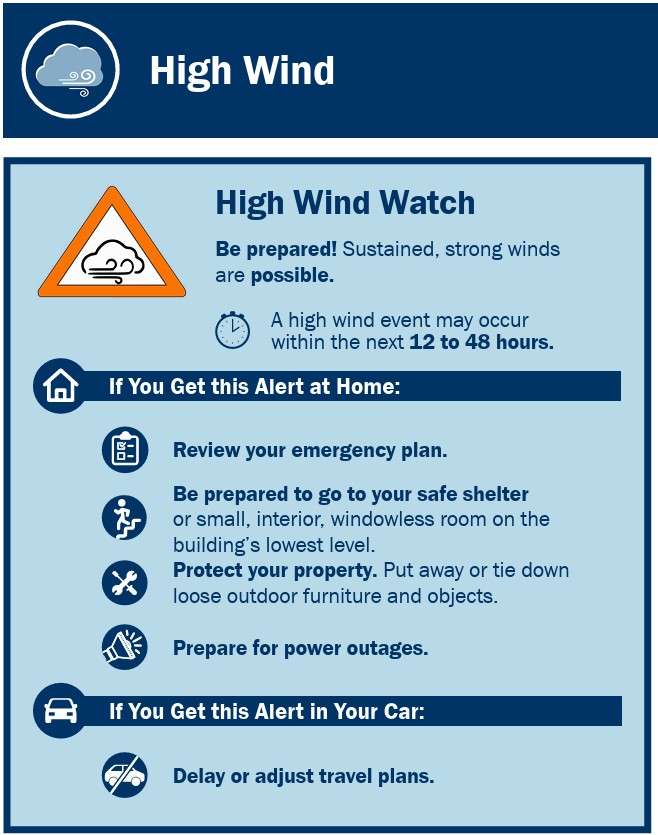
High Wind Watch
Sustained 40+ mph · OR · Gusts 58+ mph possible
Conditions are favorable for damaging winds within 12-48 hours. Review your preparedness plan and prepare to take action.
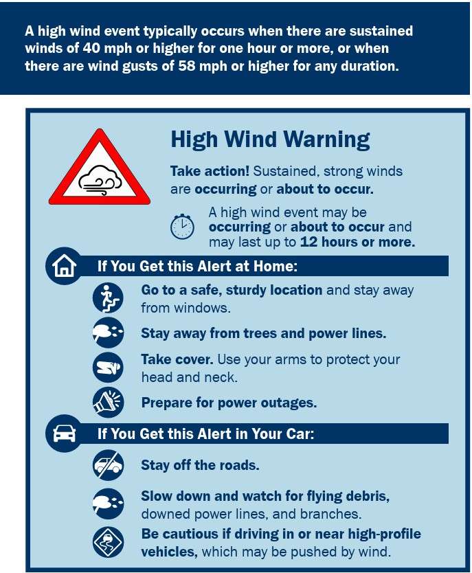
High Wind Warning
Sustained 40+ mph · OR · Gusts 58+ mph expected or occurring
Damaging winds are imminent or occurring. Move indoors. Stay away from windows. Expect power outages and downed trees.
Extreme Wind Warning
Sustained 115+ mph from major hurricane
Life-threatening hurricane-force winds expected within one hour. TAKE COVER IMMEDIATELY in an interior room on the lowest floor.
📊
Beaufort Wind Scale
▼
The Beaufort Wind Scale is a system for visually estimating wind speed based on observed conditions. Used by mariners and meteorologists for over 200 years.
📏 Beaufort Wind Force Scale
0
Calm
Smoke rises vertically. Sea surface mirror-like.
3
Gentle Breeze
Leaves and small twigs in motion. Light flags extended.
5
Fresh Breeze
Small trees in leaf begin to sway. Crested wavelets form on inland waters.
7
Near Gale
Whole trees in motion. Inconvenience felt walking against the wind.
8
Gale
Twigs broken from trees. Cars veer on the road. Generally impedes progress.
10
Storm
Trees uprooted. Considerable structural damage. Rarely experienced inland.
12
Hurricane Force
Devastation. Widespread structural damage. Trees flattened. Power lines destroyed.
📋
Before a Wind Storm — Prepare Now
▼
The actions you take before a wind event matter most. By the time the storm arrives, it's too late to secure things outside.
- Sign up for emergency alerts via the Monmouth County notification system and Wireless Emergency Alerts (WEA) on your phone.
- Secure or bring indoors all loose outdoor items: patio furniture, trash cans, grills, decorations, planters, toys, tools.
- Trim dead or weak branches from trees near your home — they are the most common cause of wind damage.
- Reinforce garage doors — they are often the first structural element to fail in high winds.
- Consider storm shutters or impact-resistant windows if you live in an exposed coastal area.
- Keep your emergency kit ready — flashlights, batteries, water, food, medications, phone charger.
- Charge phones and devices when a watch or warning is issued.
- Park vehicles in a garage or away from trees and power lines.
- Know how to shut off your utilities in case of damage.
- Have a battery-powered or hand-crank weather radio.
🚨
During a Wind Storm
▼
- Stay indoors and away from windows, glass doors, and skylights.
- Move to an interior room on the lowest level — preferably without windows.
- Do not drive during extreme wind warnings. High-profile vehicles (trucks, SUVs, trailers) are especially vulnerable to being blown off the road.
- If you must drive, reduce speed and grip the steering wheel firmly with both hands. Watch for crosswinds on bridges and open roads.
- Stay away from downed power lines — always assume they are live and energized.
- Do not use elevators during a high wind event — power may fail.
- Keep a battery-powered radio tuned to local weather updates.
- If a tree falls on your house or you hear glass breaking, move to the most interior room immediately.
- If outdoors and unable to reach shelter, find low ground away from trees and power lines.
⚠️ Danger
Wind gusts over 60 mph can flip vehicles, throw debris hundreds of feet, and bring down mature trees onto homes. Take warnings seriously and shelter immediately when alerts are issued.
✅
After a Wind Storm
▼
- Stay away from downed power lines — never assume they're safe. Report them to the utility company and 9-1-1.
- Check for damage from a safe distance before re-entering buildings. Look for structural damage, gas leaks, and broken windows.
- If you smell gas, leave immediately and call your utility company from a safe location.
- Never use a generator indoors, in a garage, or near windows — carbon monoxide poisoning is a leading cause of post-storm deaths.
- Use flashlights — never candles — in case of gas leaks or flammable debris.
- Watch for broken tree limbs and weakened branches that may still fall.
- Document damage with photos and videos before cleanup for insurance claims.
- Check on neighbors, especially elderly or those with special needs.
- Use only certified professionals for tree removal, roof repair, and electrical work.
⚠️
Wind Alerts
Watch vs Warning — know the difference, take action
🔗
Additional Resources
Wind safety, forecasts, and preparedness
🛰️ Windy.com Live Wind Map
Real-time wind speed, direction, and gust forecasts
Open in New Tab ↗